Георадары серии «ЛОЗА»
Rus Eng
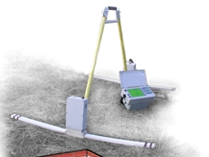
LOZA Submarine Georadar .

LOZA Submarine Georadar has been in use for 3 years in Taman bay environment (the Black Sea ). Water salt content is 18-22 0 / 00 . Submersion depth is 0.5 to 5 meters. The design of the Submarine Georadar also allows operation at greater depths. In November 2004, the radar worked at 8-10 meters depth in the river Moscow , used in autonomous mode, unassisted by a diver. Operation under up to 35 0 / 00 and at depths of up to 10-15 meters will present no problem. Greater depths will require more complex floating equipment and submarine navigation.
The design of the Submarine Georadar allows working within a large frequency range; this fact is determined by:
- registration unit with discrete frequency of 1 Ghz;
- broadband receiver with frequency range of 50 to 300 Mhz;
- design specifics of magnetic antennae.
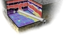
The water surrounding the unit acts as a key component of the electrode-type magnetic antennae. It is possible to redistribute the signal's frequency spectrum if we change the geometrical dimensions of the antennae and use a coordinating antenna filter. Shifting the principal spectrum components into the high-frequency range will raise space resolution figures to up to 1.6 cm.
An experimental program to test the LOZA Submarine Georadar is scheduled for the summer season (July 2006), with tests to be done in the high-frequency range with high space resolution. Boxes of low weight center and minimum floating ability will be tested during this season. The submarine boxes will use LOZA-B Georadar Unit that registers a full-wave form of sensor signal. Cable length between the surface part and the submarine part will be 30 meters .
There are two options to demonstrate operation of the unit:
• At any time during the Taman expedition (01.07.06 – 30.07.06)
• After 15.08.05, at any place customer's choice, provided the customer covers transportation costs.
Vasiliev , Kopeykin , Morozov .
|